Easter Island
& Patagonia
travel blog
See the Easter Island
& Patagonia photo gallery here
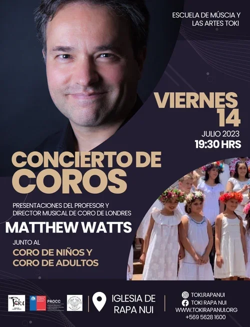
El Coro de Rapanui
In 2023 Matthew travelled to Easter Island (Rapanui) and started the remotest choir in the world, only 3512 kilometres from the nearest continent, but conveniently located for singers in downtown Hanga Roa! He would like to express his gratitude to El Coro de Rapanui for their singing and friendship. Scroll down for the full story.
Chile
Chile is the longest, narrowest and southernmost country in the world, squeezed in between the Andes, the second highest mountain range, and the Pacific, the deepest and largest of the oceans, covering a third of the planet. To the north is situated the Atacama, the world's driest desert, while in the south crawl mighty glaciers, heralding the vast white continent of Antarctica. The word Chile may in fact derive from the native Mapuche people's word chilli, meaning “where the land ends”.
In 1520 while attempting to circumnavigate the globe Ferdinand Magellan discovered the strait connecting the Atlantic and Pacific that is now named after him, and became the first European to set foot in Chile. Fifteen years later Diego de Almagro and his band of conquistadors came from Peru seeking gold, driving out the Incas and conquering her for Spain, from whom the country only gained independence in 1810. In 1973 a coup d'état led to a brutal sixteen-year military dictatorship under Augusto Pinochet, during which time thousands of critics of the regime “disappeared”. Since regaining her freedom Chile has prospered, and is now the richest country per capita in Latin America. The blue of her flag signifies the sky, the white the snow of the Andes, the red the blood that was spilt during the wars of independence, and the star her hope for the future.
Santiago
Santiago (St James) was a 1st century Christian martyr whose remains are supposed to be buried in the cathedral of Santiago in north western Spain. (On a previous trip I climbed the Pyrenees and crossed almost 500 miles of blister-inducing plains, passing Pamplona, the mighty cathedrals of Burgos and Leon and perfectly preserved Roman bridges to reach the cathedral and gain a Compostela.) Santiago de Chile, on the other hand, is situated in the foothills of the Andes along the Mapocho River, originally the homeland of the Picunches people. In 1541 in an epic journey the conquistador Pedro de Valdivia, sent by the famous Pizarro, endured almost three thousand kilometres of the tortuous Inca Trail from Cusco and seized the city for Spain.
Today Santiago is a large, modern, polluted capital city, with seven million inhabitants (40% of the country's population). The cathedral, dating from 1561, is situated on the Plaza de Armas. Where once there were gallows today there is a statue of the freedom fighter Simón Bolivar, shaded by palm trees. The streets around are enlivened by cheerful Chilenos, musicians and clowns. The city boasts the second highest building in Latin America and a central station designed by Gustavo Eiffel, but suffers from frequent earthquakes, including the 6th largest ever recorded.
Pablo Neruda
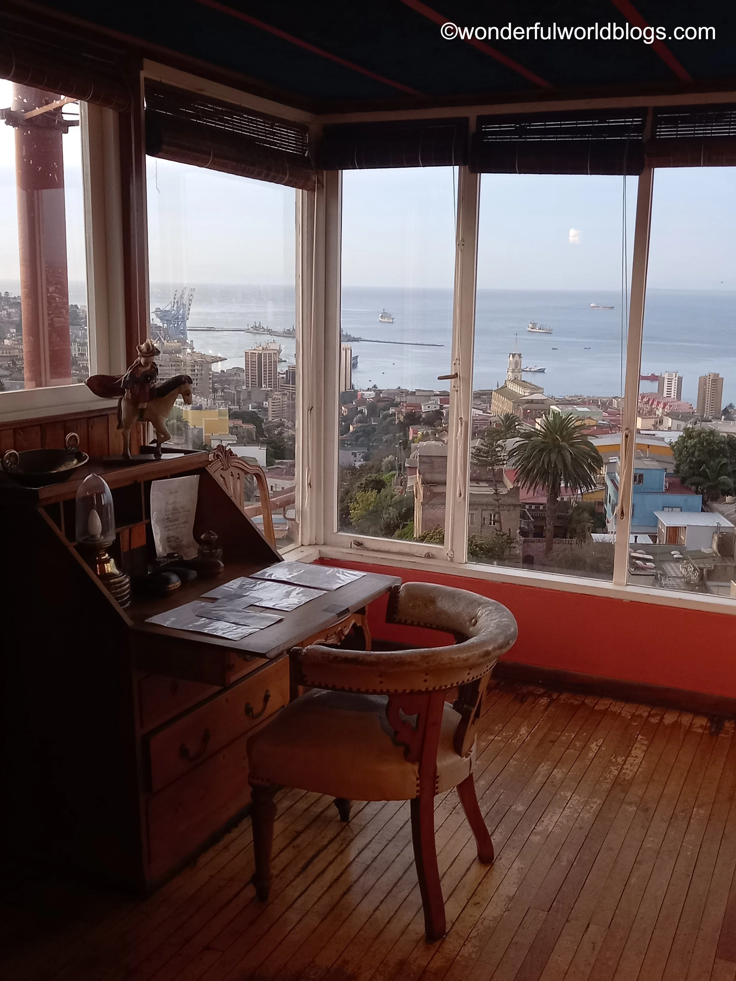
Pablo Neruda (1904-73) won the Nobel Prize for Literature and is considered Chile's national poet. His work is by turns political, romantic and surreal. His Veinte Poemas de Amor y una Canción Desperada (Twenty Love Poems and a Song of Despair) is still the best-selling work of poetry in Spanish. As a sign of someone who would go far, he published his first article - Entusiasmo y Perseverancia (Enthusiasm and Perseverance) - in a local newspaper under a pseudonym when he was only thirteen. Later on he became a member of the Chilean Communist Party and was awarded the Stalin Peace Prize. When Communism was outlawed he was forced to hide for months in the basement of a friend's flat in Valparaiso, before fleeing over the Andes to Argentina on horseback. Years later he was invited back by the President of Chile, and subsequently read his poems at the Estadio National in front of a crowd of seventy thousand people.
Neruda's house, La Chascona, is situated in a bohemian quarter of Santiago, its name inspired by the curly red hair of his lover Matilde Urrutia. The rooms reflect the poet's artistic bent and quirky sense of humour, and are packed with objects from his travels around the world: English crockery, Russian dolls, African statues, Chinese paintings and one of Matilde by Diego Rivera. There are also salt and pepper pots inscribed with the words “marijuana” and “morphine”, and several bars.
During the Pinochet coup d'état, while the house was being searched by soldiers, Neruda remarked: "Look around, but there's only one thing of danger to you here – my poetry." In his Memorial de Isla Negra he wrote: "Something stirred in my soul...and I made my own way, deciphering that fire and wrote the first faint line...and suddenly I saw the heavens unfastened and open."
Valparaiso
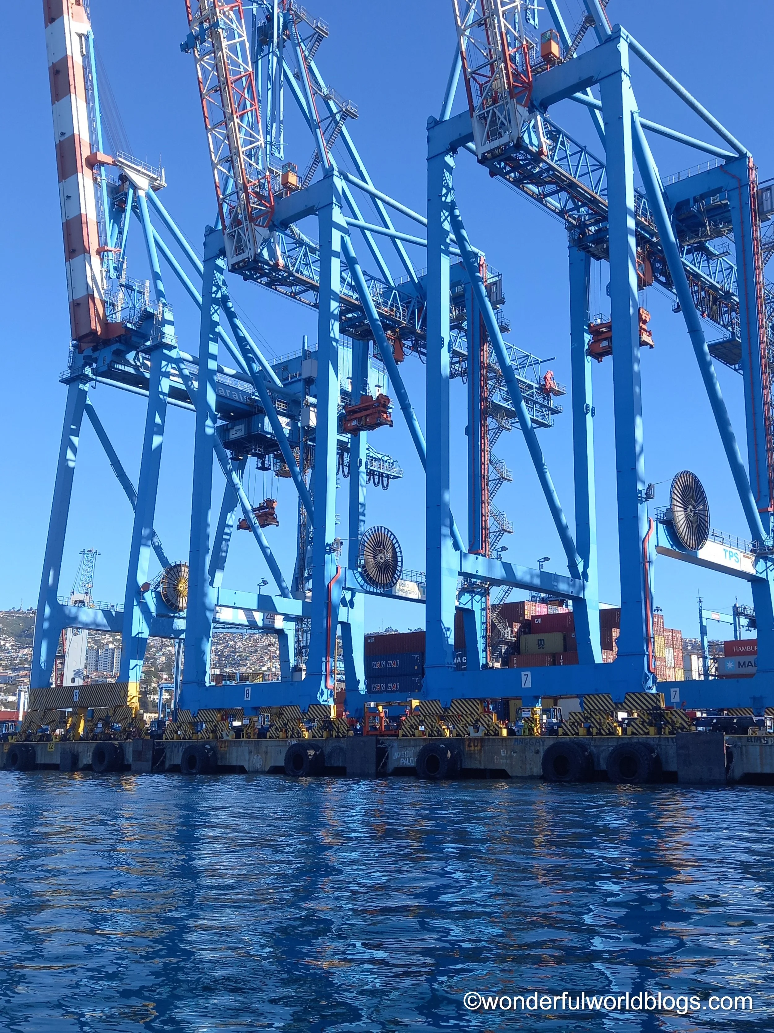
An hour from Santiago I caught my first sight of the Pacific and the rather optimistically named Valparaiso, Valley of Paradise. Originally home to the Picunche people and later raided by English pirates such as Francis Drake, this port town was a stopover for vessels including whalers navigating Cape Horn en route for the Pacific. Although its fortunes plummeted after the building of the Panama Canal today the harbour is still alive with vessels, markets and the shouts of sailors and salesmen. Precipitous roads and alleyways covered with graffiti run down from the surrounding hills past closely-packed dwellings, a haven for philosophers, painters and poets. Perched high on a hill with a view of the whole panorama is another of Neruda's quirky homes, La Sebastiana. Meanwhile out in the bay Chilean navy destroyers, massive container ships, playful little tugs and sealions rise and fall on the glistening sea.
©wonderfulworldblogs.com
If you are enjoying WWB
please Buy me a coffee
by clicking on the image above.
This will help fund the website
& future projects.
Thanks for your support!
Matthew
Rapanui
In about 1200 AD Polynesian, sailors fleeing conflict with other islanders, using only the stars and the flight of birds to navigate, sighted a triangular island formed of three volcanoes which they were to call Rapanui, meaning “big Rapa”, or Te pito o te henua, “The Navel of the World”. It was a momentous occasion in the history of mankind - the last step of our sixty-thousand-year journey out of Africa to inhabit the whole planet.
The island is among of the most isolated of all inhabited places. The nearest settlement, Pitcairn Island, is 2075 kilometres away, and has a population of only fifty, mainly descendants of the mutineers from the Bounty. The nearest continental point is Chile, 3512 kilometres away, while to the west lies Tahiti, at a distant 4231 kilometres.
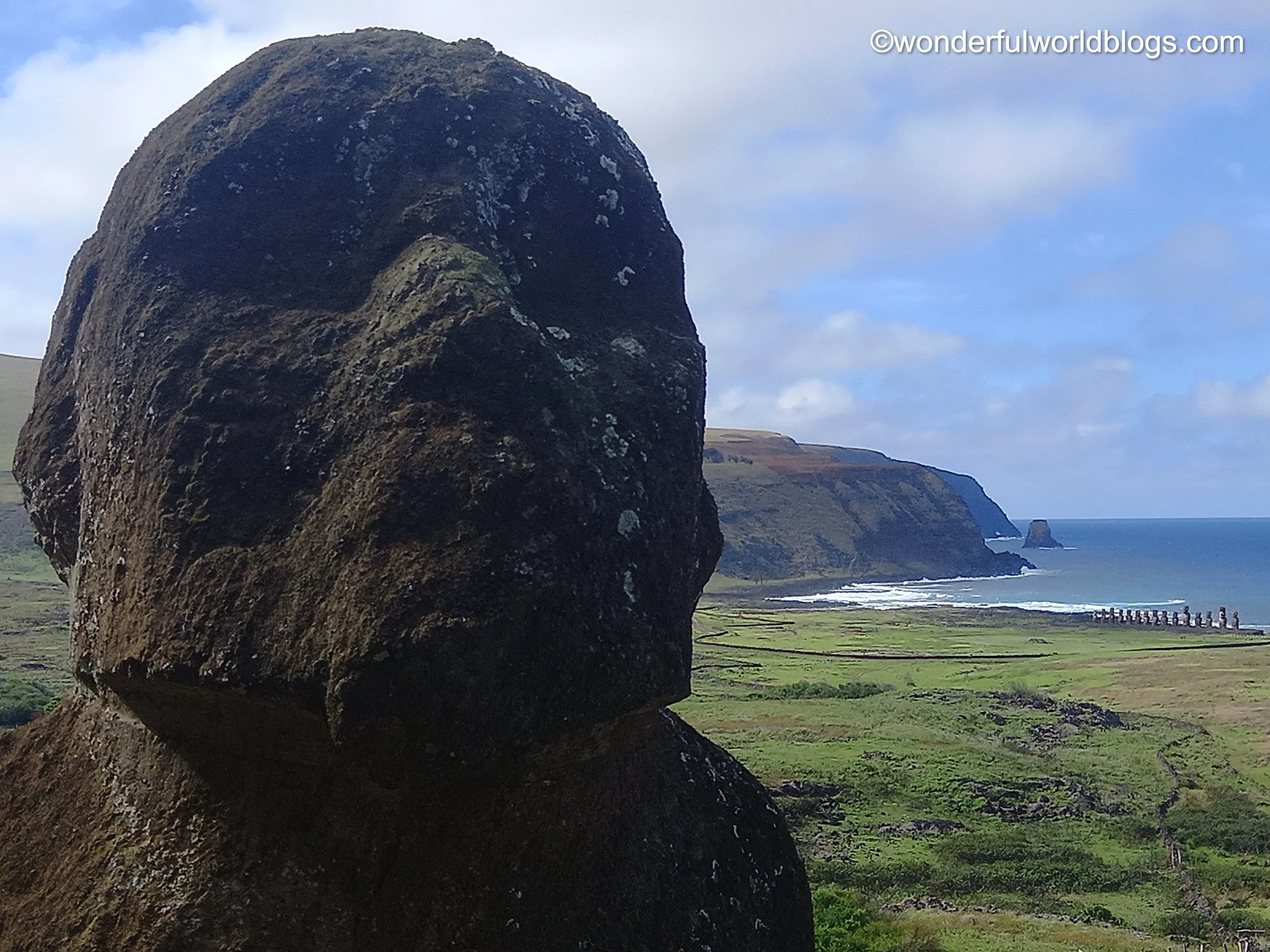
Rather than the natural beauty of its volcanic craters and its spectacular coastline the island has become famous around the world for its nearly thousand extant moai, the biggest of which at eighty tons is twice the size of the largest stones at Stonehenge. The statues, created to honour ancestors, face inland both to watch over their descendants, and because the islanders for over half a millennium believed there was no civilisation beyond their shores.
The fate of the moai is linked to that of the islanders. When Captain Cook visited in 1774 he found virtually all of the statues toppled or defaced, and the population impoverished and struggling to survive. Tragically it seems that the statues, despite the huge labour involved in their construction and placement around the coastline, had been intentionally toppled, perhaps as a kind of revenge for their failure to protect the Rapanui from decline.
The reasons for this are much debated. Some say that internal conflict and the cutting down of the island's once rich rainforests set the people on their downward path, although there is little evidence for the former and the islanders demonstrated great expertise in fishing and farming the rich volcanic soil. What is beyond doubt is that the arrival of outsiders, as in so many places around the world, was disastrous for the indigenous population. On Easter Day 1722 when the Dutch explorer Roggeveen sighted the island the population was about 2500. But by the 1860s due to European diseases, Peruvian slavery expeditions and emigration there were only 111 left. Today about half of the population are Rapanui, all of them descendants of those 111. In 1866 Chile annexed La Isla de Pascua (Easter Island), although it was not until the mid-twentieth century that they granted the residents Chilean citizenship. In 1900, in a final indignity, much of the island was turned into a sheep ranch and the people were imprisoned in their own town, Hanga Roa, still the only densely populated part of the island.
Today, however, with a healthy-sized population of 7000, sustainable agriculture and fishing and world-famous tourist attractions, the future looks bright. Perhaps the moai have looked after their people after all. The island boasts one of the longest runways in the Southern Hemisphere. It was elongated by NASA to accommodate the emergency landing of the space shuttle. What a meeting that would have been - moai and a spaceship.
Despite the pride and hardiness of the people their cultural traditions remain fragile. The ability to read Rongorongo, their ancient hieroglyph-like script, has been lost and has defied modern attempts to decipher it. Today only about 1300 people speak its modern equivalent, many of whom are older. And in the music school where I will be working only about a dozen children still sing the songs of their ancestors.
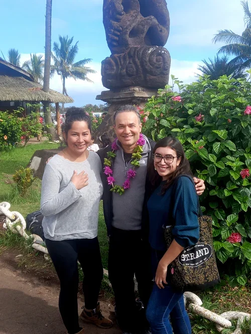
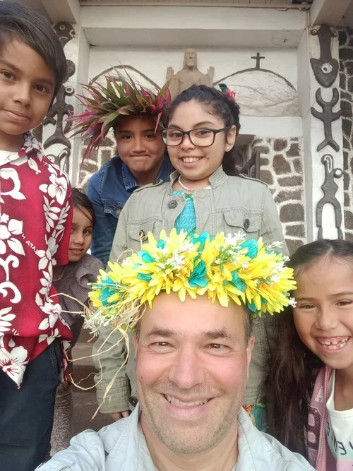
It is amazing how quickly you form an opinion of a place. On arrival there is a giant multi-coloured “Iorana” (“welcome”) sign, and the single arrivals hall is built from wood in the style of a traditional meeting house, with mosaics of turtles under foot and a giant carved whale. (Compare this with most countries’ terminals – huge voids of metal, plastic and glass.) No-one checked my passport or entry form, but the sole official asked me twice if I was bringing in any fruit or honey. After collecting my bag I walked straight out to be greeted by the smiling faces of my hosts from the music school, who hung a garland of flowers around my neck (real ones, they told me, not like the plastic ones you receive in Hawaii).
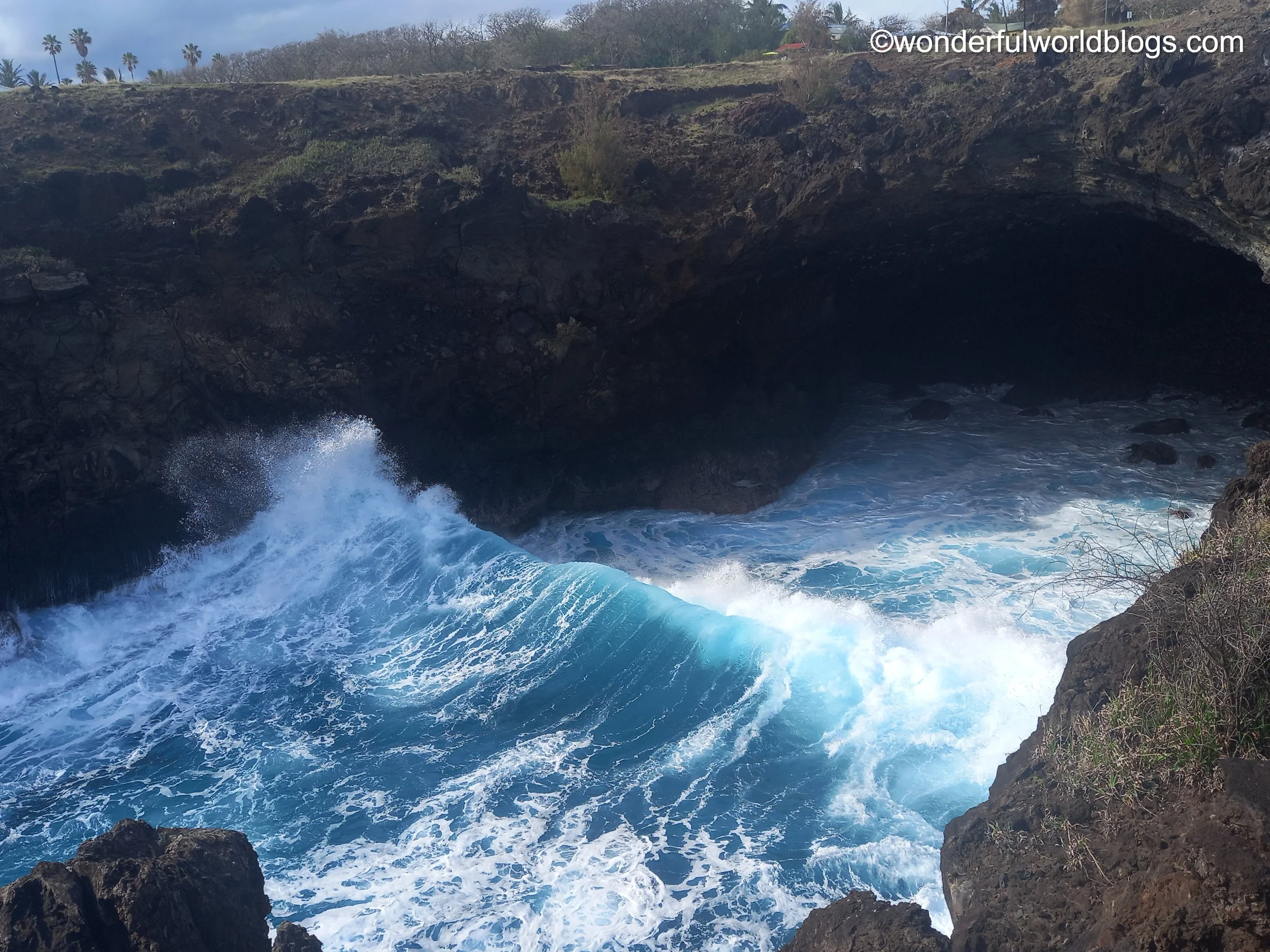
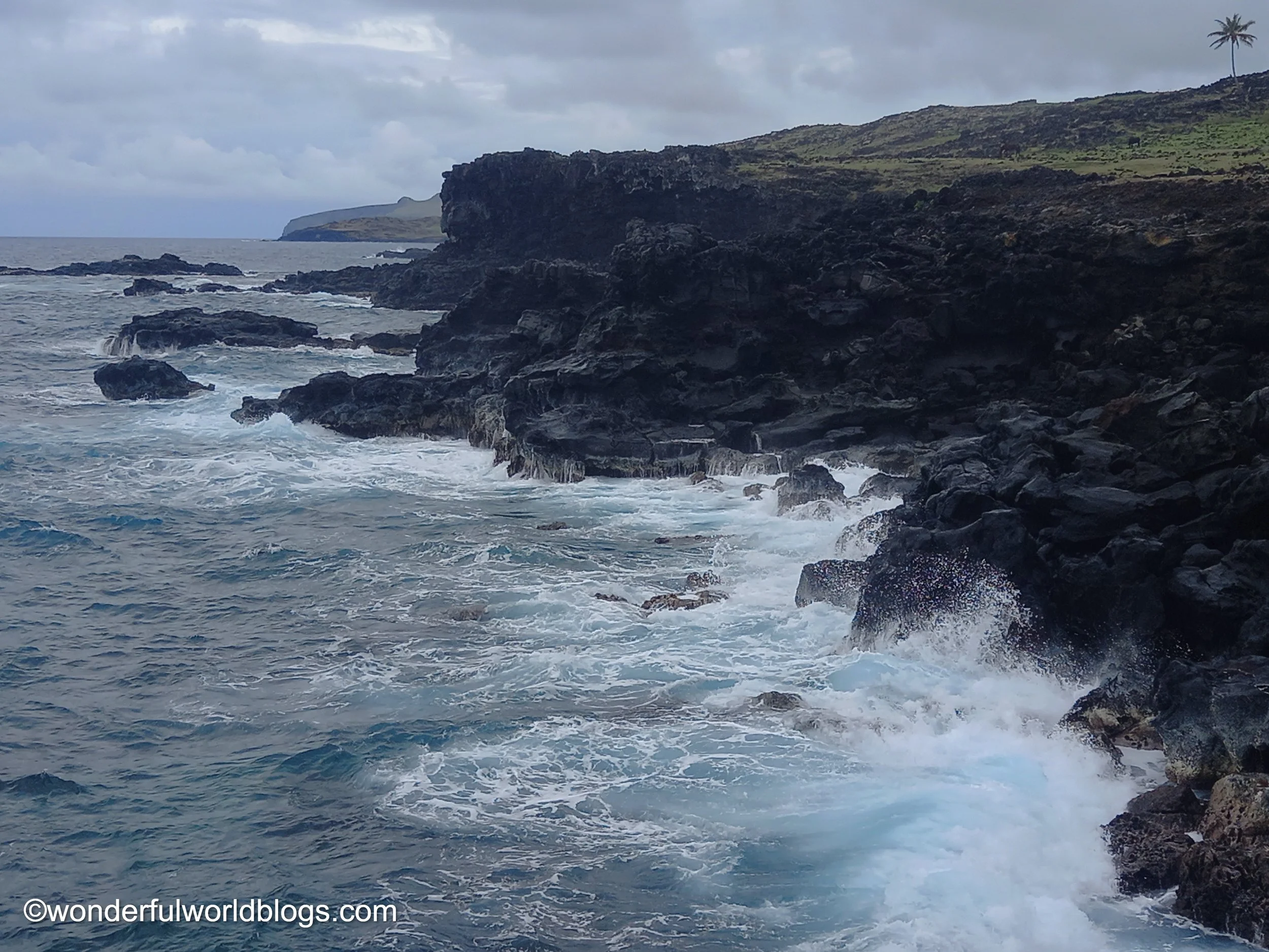
Driving along small, tropical country lanes, lined with houses decorated with sculptures and murals, you reach the coast, where powerful waves break on dark volcanic cliffs. Off-shore container ships lie at anchor at this tiny oasis of civilisation, resting from their long, lonely journeys across the vast Pacific.
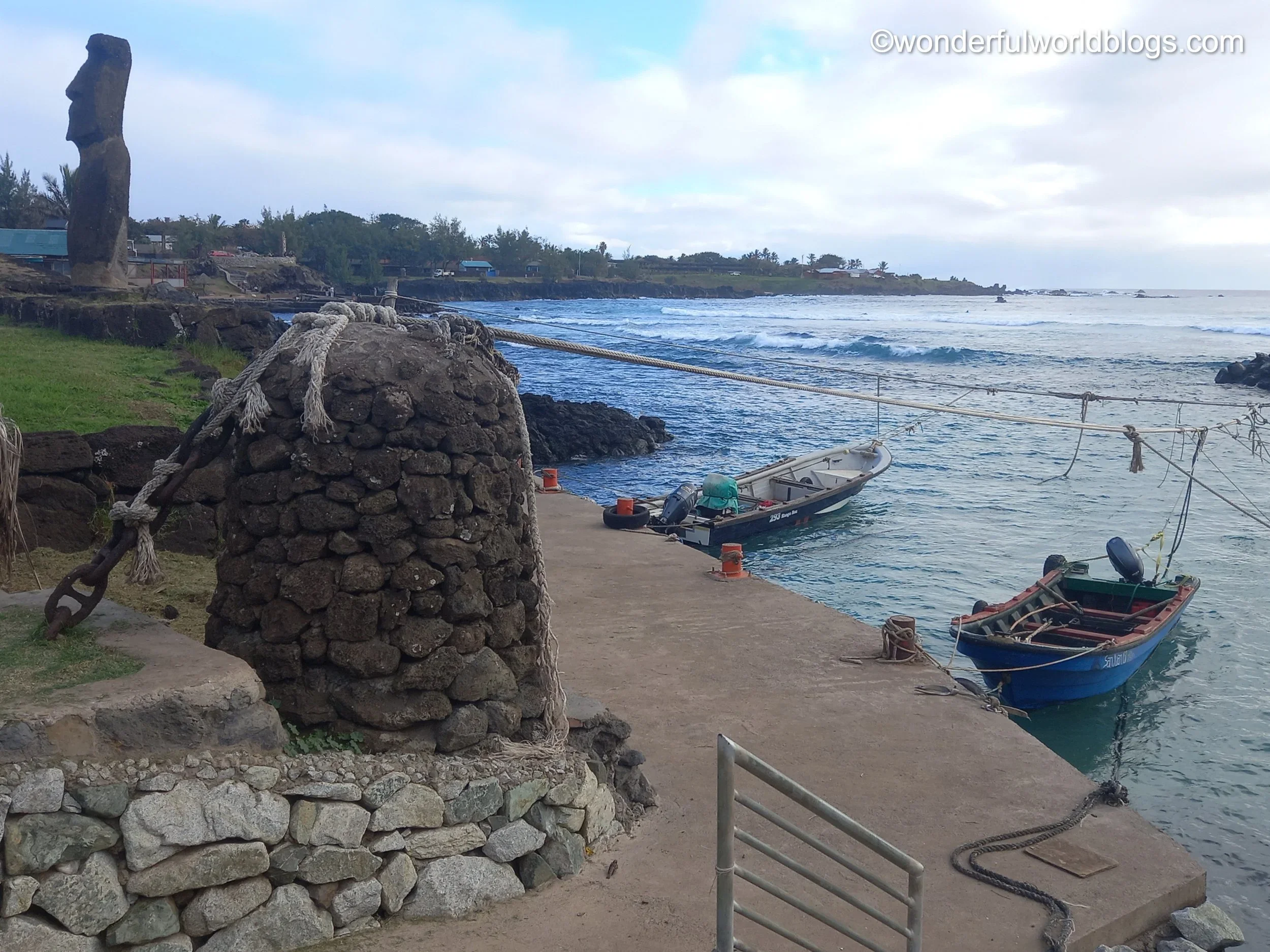
Although the locals insist on calling it downtown it would be easy to drive through the capital Hanga Roa without realising it. There are no tall buildings. The main street is lined by one or two story houses and everything is human in scale, the moai being perhaps the tallest objects around. The prices in the shops are high though, double that of London, but then some of the produce has had to come a long way. Continuing down to the tiny harbour, where small boats and giant sea turtles bob on the gentle waves, you see your first moai, towering above you - a giant, friendly, androgynous-looking ancestor. Each statue is different, and not just in size. Some have protruding chins, others bigger than usual noses, while the generous swell of a belly may indicate the ancestor’s prosperity.
Later, at the small wooden cultural centre overlooking the harbour, I met the child and adult singers for the first time, a mixture of Chilenos and Rapanui. I am struck by the power and emotion of their singing, the ease of their movements and their keen ears. These are certainly people with voices that deserve to be heard.
The moai watch over us, their backs to the sea from whence they came, silhouetted against the ever-changing sky. Outside Hanga Roa the land is quiet, like the time before the first people arrived. A shadow appears on the ocean, creeping up slowly, inconspicuously, before horses ride forth in a cascade of white. In the quarry the moai sleep, forever waiting for the Rapanui to set them free.
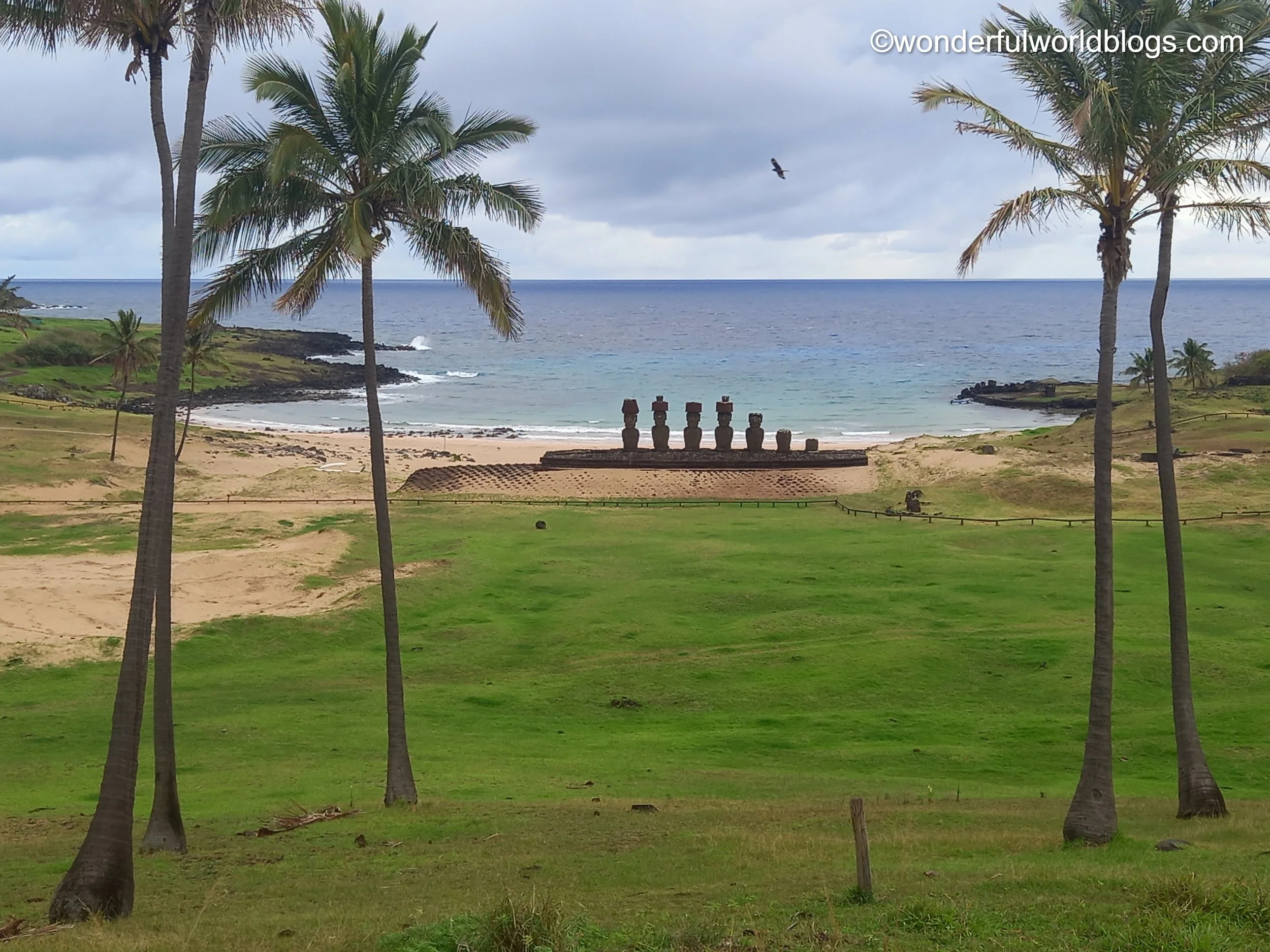
To the north of the island is the pristine sandy beach of Anakena, one of only a few safe landing places, framed by gently sloping hills and shaded by tall palms. It was here that the first settlers pulled up their boats after their long voyage from the west, and where their King was to live. In the centre of the beach on a ceremonial Ahu platform, onto which even today you are forbidden to step, the Rapanui raised a line of moai (one restored by the Norwegian ethnographer Thor Heyerdahl), to honour their brave ancestors.
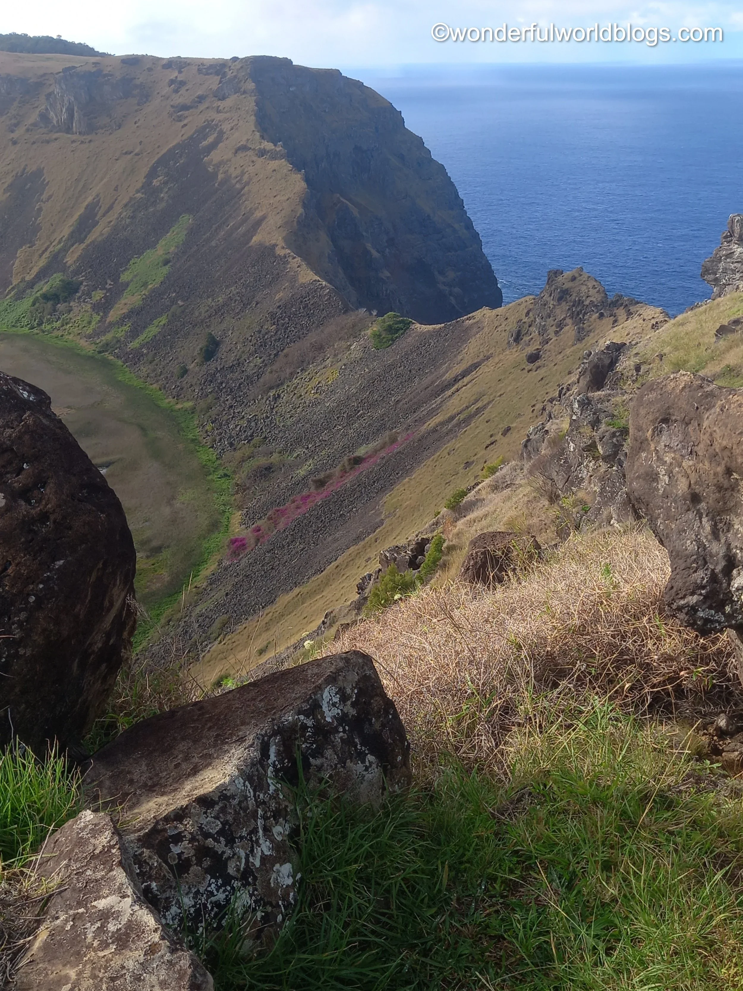
I followed the coast west and then south, walking the twenty or more kilometres back to Hanga Roa. Powerful Pacific waves crashed on jagged volcanic rocks and birds soared above plunging cliffs. For a full five hours I met not a soul and saw only a single ruined shack. My only company were wild horses and herds of wandering cows. Strewn across the grassy slopes, as on much of the island, were small boulders, once fiery projectiles thrown as if from a million medieval trebuchets, mapping out ancient eruptions. Between the stones were little red and yellow flowers, from which small white butterflies were disturbed as I walked by, and occasional animal skeletons, bleached white over time. I encountered the occasional lonely palm and several ruined Ahu, their huge stones once skilfully, but futilely erected by some act of will and process of which we know not, until the low silhouette of the now familiar Hanga Roa came into view.
Due to the quality of the rock found there the Rano Raraku quarry was the birthplace of the vast majority of the moai, and indeed the centre of religious megalithism in the whole of Polynesia. From its steep slopes the ancestors were released from their beds of rock and passed down on a conveyor belt, now stopped for the ages as if its workers had downed tools and gone on strike. Some statues - the largest twenty-one metres in height - lie on their backs, unformed, while others stand upright, with features as yet unrevealed. Different workers specialised in carving the head, nose or eyes, and could create a new moai in only three weeks.
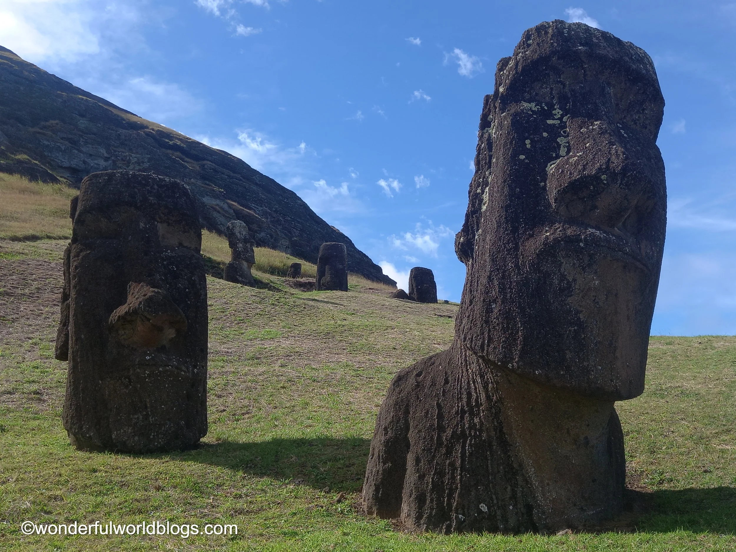
There are many theories as to how they were transported across the island - rolled on tree trunks, pulled on sleighs or, perhaps most convincingly, walked by teams with ropes attached on each side, as the old stories tell. What is for sure is that it was a miracle of labour for a population of only twelve thousand at its height to create a thousand or more statues. (My guide said she there were two uncounted ones in her back yard.) The moai are amongst the most famous statues in the world, up there with the Statue of Liberty, Michelangelo's David, and the Sphinx, and have gained the honour, like Munch's Scream, of having their own emoji🗿. Circling the hill you come to a lone moai with a very different profile to the rest, that may well have been of a black African, who came to dwell on these shores from halfway around the world.
Within a few hundred metres of the quarry, with of backdrop of cliffs and white-crested waves - a setting that any sculptor would surely view with envy - stands the most famous gathering of moai of them all, fifteen in total, at Tongariki. Only by standing there yourself can you experience the full power of their monumental size and stern authority. To the sides the platform is extended and decorated with egg-shaped stones, probably symbolising fertility. (Although the moai are androgynous in appearance a few have been recognised as females.) Unlike other statues that were toppled by disgruntled Rapanui, in 1960 a huge earthquake and subsequent tsunami thundered across the Pacific from Japan to Chile and knocked those at Tongariki from their ahu. (Even today there are tsunami evacuation stations on the island.) They were restored, at a cost of millions of pounds, by a Japanese firm, in the opinion of my guide, because their government wished to gain access to Rapanui's rich mineral resources.
As disillusionment grew with the authority of the moai, and perhaps with the labour involved in their creation, their era gave way to the worship of the Mahoke or frigate bird, and its human embodiment, the Birdman. An annual cycle of ceremonial activities was centred on the village of Orongo, perched high on the rim of the Rano Kau volcano, south of Hanga Roa. Its low stone buildings are only 250 years old, but are Neolithic in appearance, reminding me of Skara Brae in Orkney, Scotland. At the time of the nesting of birds on the tiny islands offshore foolhardy men would scale down the three-hundred metre cliff and swim the two kilometres of wild waters and try to be the first to bring back an egg intact. He who did was declared El Hombre Pajaro, The Birdman. This era lasted until as late as the mid-19th century, when Catholic missionaries sadly ended this unique culture once and for all.
Up until 1988 the Rapanui would collect fresh water from the crater of the Rano Kau volcano, bringing it to town by horse. In the crater fruit grows and in recent times the Rapamycin bacteria has been discovered, used as a natural medicine in organ transplants. I was far from home, but felt closer when one of the locals, on hearing I was English, admitted to being a big Lady Diana fan, and then showed me the exact spot from where British sailors had taken the moai that now stands in the British Museum. Hoahakananai'a, El Amigo Robado (The Stolen Friend), adorned with unique petroglyphs, was taken from here in 1868 and presented to Queen Victoria as a gift. There is a strong desire for his return. One lady I met had been part of a delegation that travelled all the way to London to call for his repatriation. I will certainly see him with different eyes when I encounter him again.
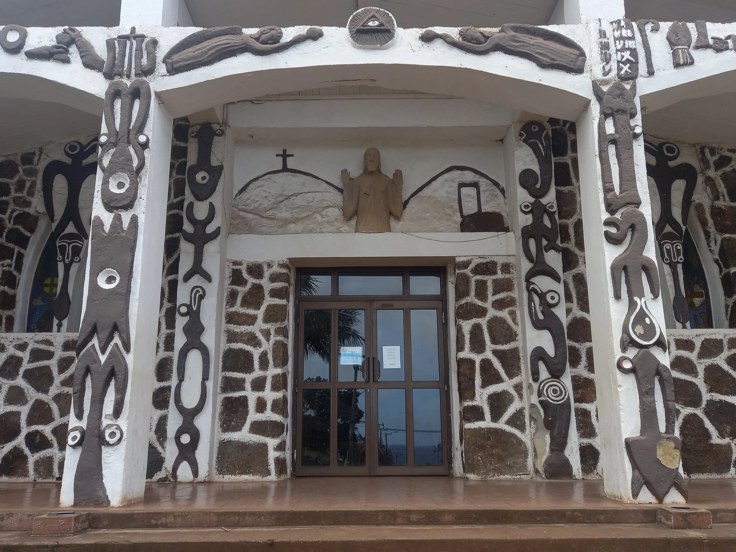
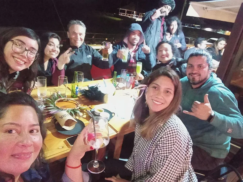
The inaugural concert of Los Coros de Rapanui (children's and adult choirs) took place in the main church on the island, built by a German monk, Sebastian Englert. La iglesia combines Catholic iconography with indigenous images - birds and fish being prominent. Although there is congregational singing at services, in Spanish and Rapanui, few if any (?) choral concerts have taken part in the past. Nevertheless, as I was to find out on numerous occasions - catching a lift with two characterful sailors, and at a well-oiled late-night party around a fire - it seems that almost everyone here sings and plays the guitar well, so there is a rich vein of talent. As well as international pop songs you can often hear Rapanui songs, sung solo in a modern, folky style. I was surprised to hear that even on this small island all of the singers made new friends.
"El aeropuerto, es enorme!", exclaimed a young boy, who perhaps had not left Rapanui before. Indeed, the crowds of anonymous people at Santiago airport created a very different atmosphere to that of the wooden arrivals hall on Rapanui. Flying over the snowy peaks of the Andes en route to Patagonia I connected in Buenos Aires, a grand, chilly city where I saw homeless people for the first time in a while.
©wonderfulworldblogs.com
If you are enjoying WWB
please Buy me a coffee
by clicking on the image above.
This will help fund the website
& future projects.
Thanks for your support!
Matthew
Patagonia
Patagonia is a million square kilometres of wild, sparsely-populated landscapes at the southern tip of the world, holding the mighty Atlantic and Pacific oceans apart. Where the Andes meet the Southern Ocean the land curls like the tail of one of the dinosaurs that once roamed there, and is home to penguins, killer whales and Welsh tea shops, following a wave of immigration in the 19th century. Inspiring authors such as WH Hudson and Bruce Chatwin this vast region has attracted personalities ranging from Francis Drake to Charles Darwin. Butch Cassidy and the Sundance Kid chose this remote land as the perfect place to escape from the law.
When Ferdinand Magellan made landfall in 1520, before becoming the first European to cross the Pacific, the region was home to hunters - the Ona and Haugh peoples - and fishermen - the Yamana and Alcalufe, although hardy people had lived there since at least the 10th century BC. Due to their moccasins Magellan thought the local people's feet appeared huge, which may have given rise to the name Patagonia, "land of the big feet." In 1881 a Boundary Treaty split the land between Chile (10%) and Argentina (90%) but today many locals from either side think of themselves first and foremost as proud Patagonians, separate from their Latino neighbours to the north.
El Calafate
The Argentinian town of El Calafate is named after a berry which once eaten is said to guarantee your return to Patagonia. Surrounded by vast plains and snowy mountains and situated on the shores of Lago Argentino where flamingos feed, the area was initially home to the Aonikenk people who herded guanacos (like a llama, but as tall as a man).
Calafate has wide streets named after revolutionary figures and events, locals that avoid your gaze and an icy wind. As inflation is rife people carry around huge wads of cash, though a wallet stuffed with notes amounts to only a few hundred pounds and may be empty again the next day. Fortunately the town had one of the friendliest hostels I have stayed in - América del Sur - with its own restaurant and bar next to a roaring fire, run by a red-faced Argentinian chef and wine connoisseur.
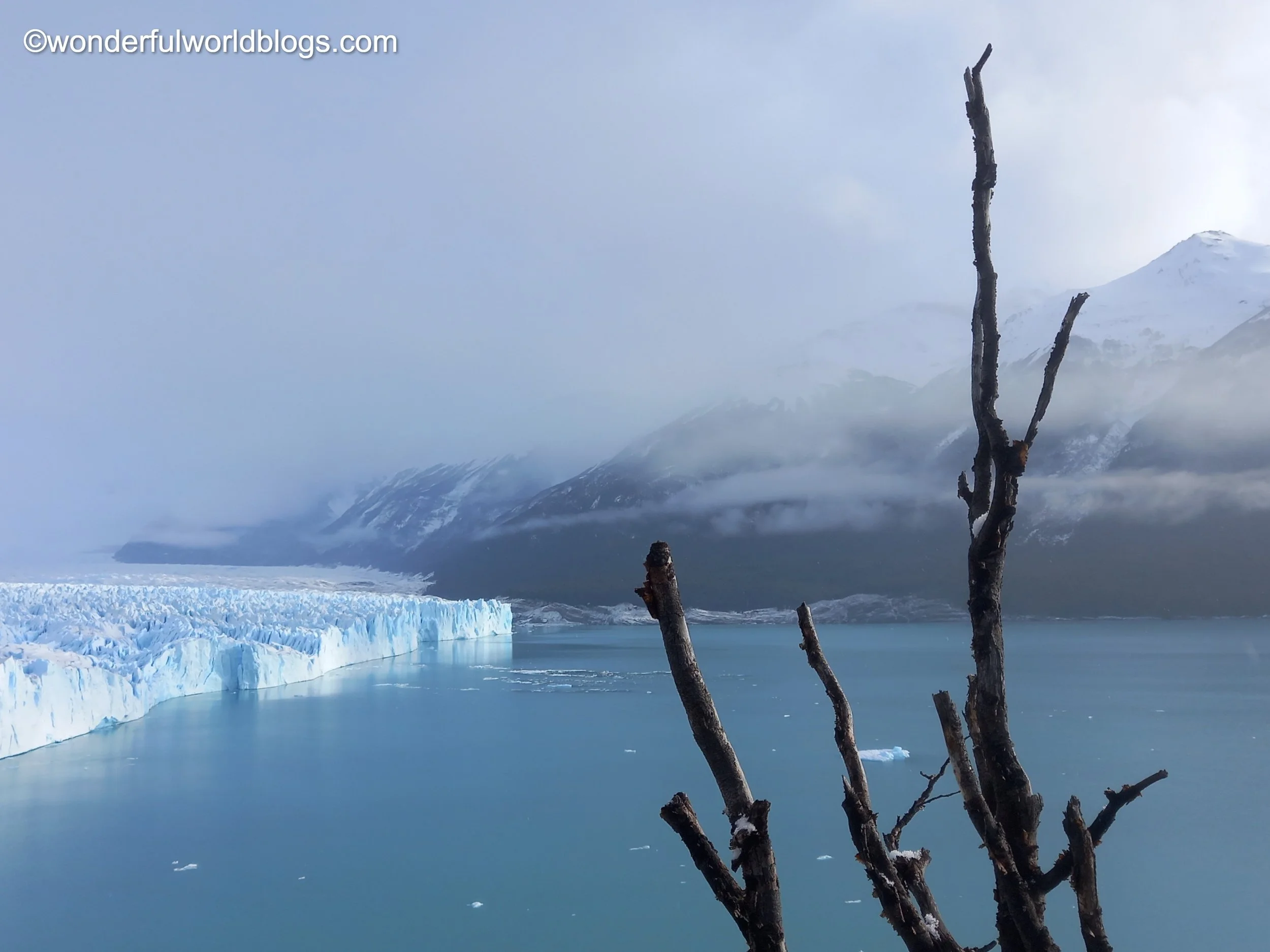
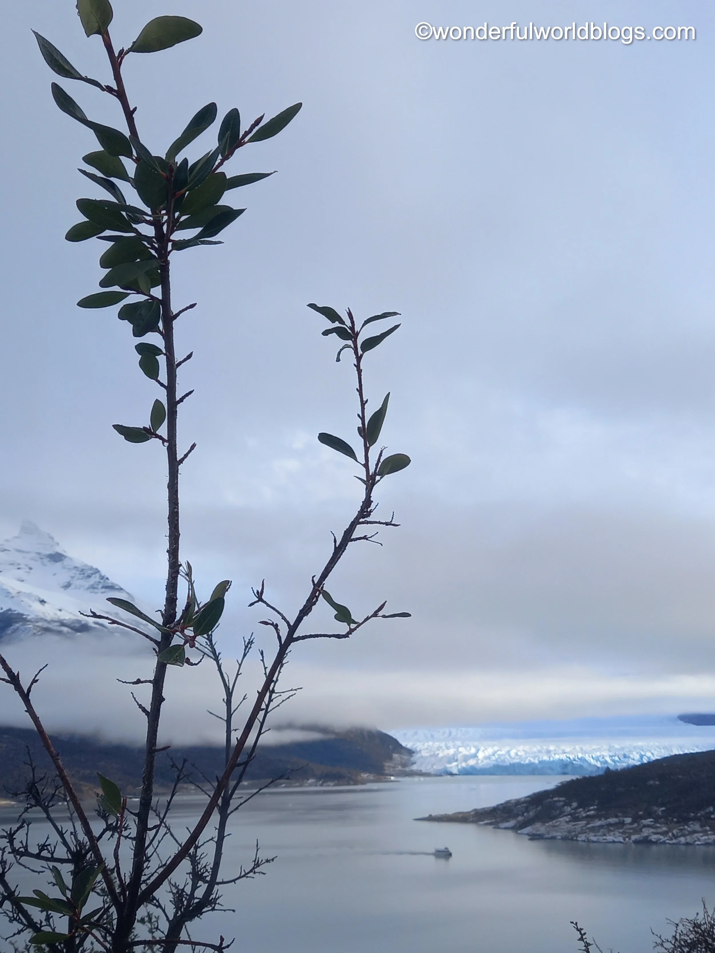
Perito Moreno
Outside of the Himalayas and Antarctica Patagonia has some of the mightiest glaciers in the world, and none is more spectacular than Perito Moreno, named after a scientist and diplomat. It is four kilometres wide, has 250 square kilometres of honeycombed ice, and stands sixty metres above El Lago Argentino, with an extra hundred metres under the water. In the afternoons, heralded by sounds like gunshots, huge chunks of ice plummet into the lake, setting off waves across the otherwise still waters.
El Chaltén
Too early on a freezing morning I set off on a rickety bus travelling north. Before dawn a light blue watercolour spread across the dark sky illuminating impenetrable clouds like boats on an ocean. Then yellows, pinks, purples and oranges soaked the canvas until, with a final flourish, blood red streaks cut across the sky, above the cold, endless plain.
Three hours north from El Calafate on the banks of Río de las Vueltas and surrounded by a ring of spectacular mountains, sits the youngest town in Argentina, El Chaltén, which was only founded in 1985. The name comes from the Tehuelche language and means “smoking” or “blue mountain”, both entirety apt descriptions of the peaks above.
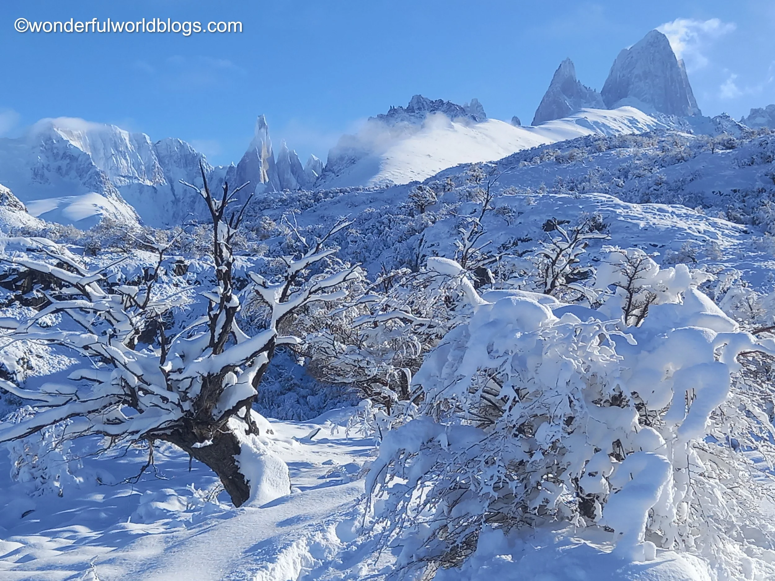
The next morning the valley was under a blanket of snow and I climbed up through a wooded wonderland to the lower slopes of Mount Fitz Roy, named after the captain of the Beagle who toured the Santa Cruz region in the mid-19th century. With snow still falling visibility was little more than a hundred metres and I was forced to turn back at the frozen Lago Capri, after waiting a while to listen to the silence. Above, veiled by the wintery sky, stood the 3400 metre peak, its slippery slabs of vertical stone having beckoned even some of the most experienced of climbers to their deaths.
Setting off the next day for Cerro Torre in -7°C, the snow lay deep and crisp and even, but at first I walked with confidence with my newly purchased crampons. As soon as I attempted the first climb, however, I experienced an exhausting sensation, akin to wading through water, which I guess I was. Five hours later I was still going and frostbite felt a real possibility. In the deadening wintery silence I thought of turning back but spotted fresh footprints and decided to follow them to a mirador (viewpoint). After an hour or so scrambling between bushes and up rocky slopes, I crested a ridge and was rewarded with a fairy-tale view - a line of jagged peaks standing out like castle turrets against the now blue sky, including the legendary Monte Fitz Roy and the dagger-like Cerro Torre.
Having caught up with the trio of walkers whose steps had been my guide I forged ahead by myself. But the path was buried and I soon realised I had lost it and was following the tracks of some animal, tramping through snow above my knees, with scraggly bushes tearing at my coat. The foliage was impassable and I had to admit defeat. With my feet dangerously cold I was relieved to stagger back into El Chaltén several hours later.
From now on I will be heading south, as far south as is possible without stepping foot on Antarctica itself.
Puerto Natales
On a five-hour bus journey across a frozen desert moonscape, you cover but a tiny part of Patagonia. Far in the distance I spied the mountains of Torres del Paine and crossed la frontera. On the Argentinian side the border was guarded by bored officials and a rather sleepy looking guard dog, while entering Chile you get the whole airport treatment in a hall adorned with a picture of their handsome young bearded President, who has the air of an opera singer (a tenor, in my opinion). Even the blonde sniffer dog looked a whole lot more interested than its Argentinian counterpart (and fortunately he was well enough trained to leave my cheese sandwich alone).
The bus descended to a shimmering fjord and the town of Puerto Natales, made up of colourfully painted tin shacks of no more two stories. My first impression - that these were first generation buildings - was born out later when I saw photos in the town's museum. The streets have changed little in the intervening century. I visited El Cementerio Padre Alberto Hurtado, founded in 1914, walking down narrow passageways between family tombs with faded black and white photos of once warm, loving couples now sleeping under a duvet of snow. In the distance, as the sun set, I heard the metallic groans of great ships mooring in the harbour, while closer by played a solitary saxophone.
At the close of the evening I walked along the coast to the port, feeling a tinge of fear at this unwelcoming place, where perhaps I should not have been. Here there is another frontier, where blinding lights meet the all-enveloping darkness of the ocean. Where the whirring, beeping and screeching of giant trucks and the quiet silhouettes of container ships meet the gentle squawking of sea birds, who have also travelled far across the southern seas. Passing anonymous figures clad in fluorescent garbs I came across a small park, now a giant bowl of ice, with a child's swing frozen still, unloved on this winter's night.
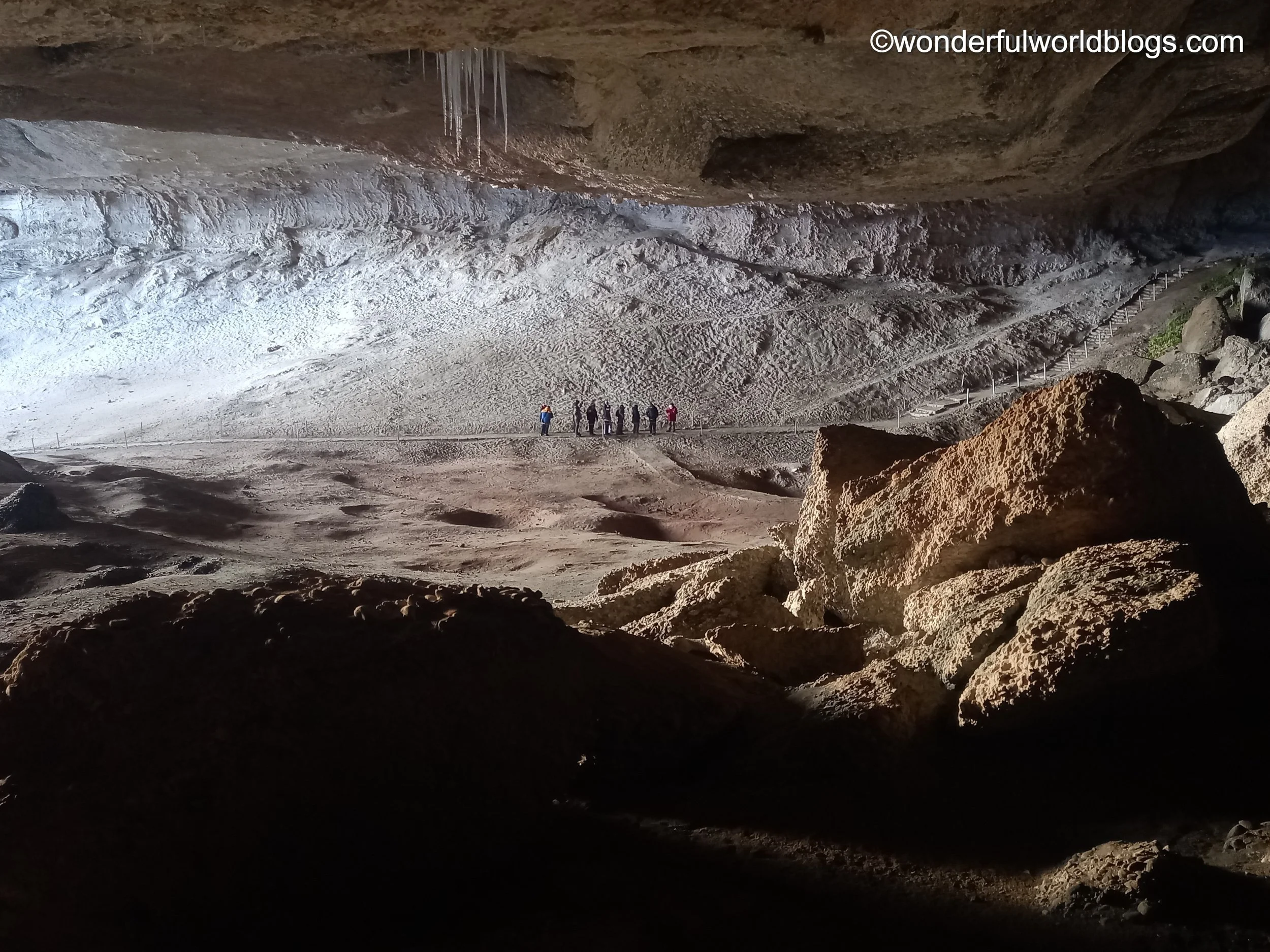
Las Cuevas de Milodón
Las Cuevas de Milodón date back eighty million years, when they were formed at the bottom of an ancient sea. The huge gaping mouth of the main cave, thirty metres high, eighty wide and two hundred deep, leads to one of the most important archaeological and palaeontological sites in the whole of the Americas. Here the remains of sabre-toothed tigers (the cheerfully named smilodon) and a large piece of intact mylodon (ground sloth) skin were found, more than fourteen thousand years old. Humans once dwelt here too. Despite the size of the cave mouth the air inside is warmer than you might expect. They lived off horses and guanacos, but were themselves prey to pumas and tigers.
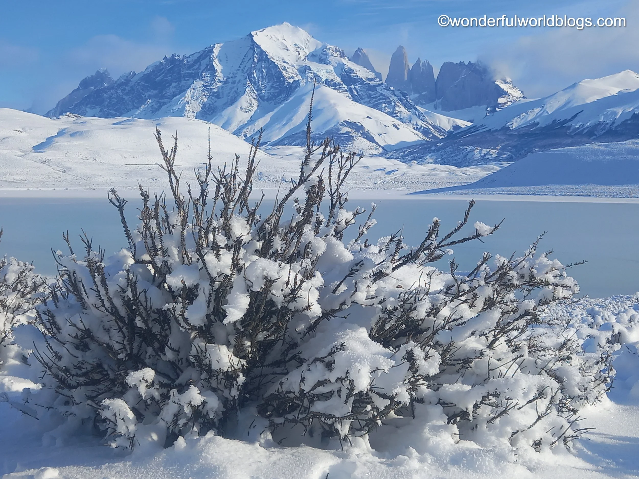
Torres del Paine
The natural wonders of Las Torres del Paine (The Towers of Paine), part of the Southern Patagonian Ice Field, are one of the continent's great national parks. They were home to the Aonikenk or Tehuelche people for more than three thousand years until their land and life were stolen from them by settlers. Now they dwell only in museums and memories. The people may have been driven out but the land is still home to eagles and condors, swooping over the plains with a wingspan of up to ten feet, herds of guanacos feeding amongst the frosty bushes, and their foe, the kings of Las Torres, the pumas, creeping like a dark shadow, evading the gaze of guanacos and smartphones alike. I visited twice. One day all was hidden, earth, sky and water merging into an impenetrable white, the vistas only revealing themselves momentarily, tantalisingly, like Salome from behind her veil. I returned the next day and was driven around by a patient, smiling lady called Rosario. (The park is inaccessible by foot at this time of year due to the deep snow, somewhat to the relief of my toes.) We crossed the plains and circled the fortress-like Torres with their sheer rock faces, only one of which has ever been climbed, reflected in the waters below.
Adiós then Puerto Natales, where gently sloping hills run down to the icy fiord, where a maze of streets confuse the senses, where a dog sleeps undisturbed on the floor of the bus station and the dead rest peacefully under a blanket of snow, and where I found a home for a while amongst friendly people.
Punta Arenas
La Ruta del Fin del Mundo (the Road at the End of the World) has become popular with soon to be married couples (El Fin del Mundo only comes after marriage, apparently). It takes three hours by bus across featureless plains to get from Puerto Natales to Punta Arenas ("sandy point"), founded in 1848 as a penal colony and now the biggest city in Southern Patagonia. Located between the two largest freshwater reserves in the world (the Southern Ice Fields and Antarctica, 1400 kilometers away) the city recently celebrated its 500th anniversary. It is the southernmost point of the entire continental landmass of the Americas. (Tierra del Fuego is further south, but an island.) Before the opening of the Panama Canal in 1914 Punta Arenas was the main port for ships travelling between the Atlantic and Pacific oceans which, along with a gold rush in the 1890s, explains the grand architecture that can be seen in its centre.
Along the seafront are a series of monuments to ship-builders and owners, merchant sailors, whalers, sealion hunters and explorers. The Basque Juan Sebastián Elcano was the first person to circumnavigate the world in 1519-22. The Chilean captain Luis Pardo Villalón rescued twenty-two of Shackleton's shipmates from Elephant Island in 1916. There is also a plaque for the Kawesqar people, who "bequeathed the spiritual strength of the sea to the region." The piers here, the older ones now crumbling into the sea, are rich with history. To take just one example, in 1897 a Belgian navy officer Adrien de Gerlache de Gomery set sail aboard the ship Belgica on the first scientific expedition to the Antarctic, with crew including the Norwegian Armundsen (latterly the conqueror of the South Pole) and the American, Cook (the disputed conqueror of the North Pole). They were not to return for two years after becoming trapped in the ice, many of the crew perishing or succumbing to madness.
In 1843 the Chilean vessel Goleta Ancud anchored at Punta Santa Ana on the Straight of Magellan, about fifty kilometres south of Punta Arenas, and laid claim to the Straight and the surrounding territory. Not a moment too soon! Within 24 hours a French expedition in the steam-wheeled war frigate Le Phaéton arrived, but to no avail. The Chilenos set about establishing a fort on the steep coastline and named it Fuerte Bulnes after their President. But due to the exposed setting (there was driving snow and a wicked windchill when I visited) and the lack of land for a larger settlement the site was abandoned within a few years, and a new town built, which became Punta Arenas. A century after its foundation a replica of the fort was constructed, which gives a good impression of what life would have been like for the original inhabitants.
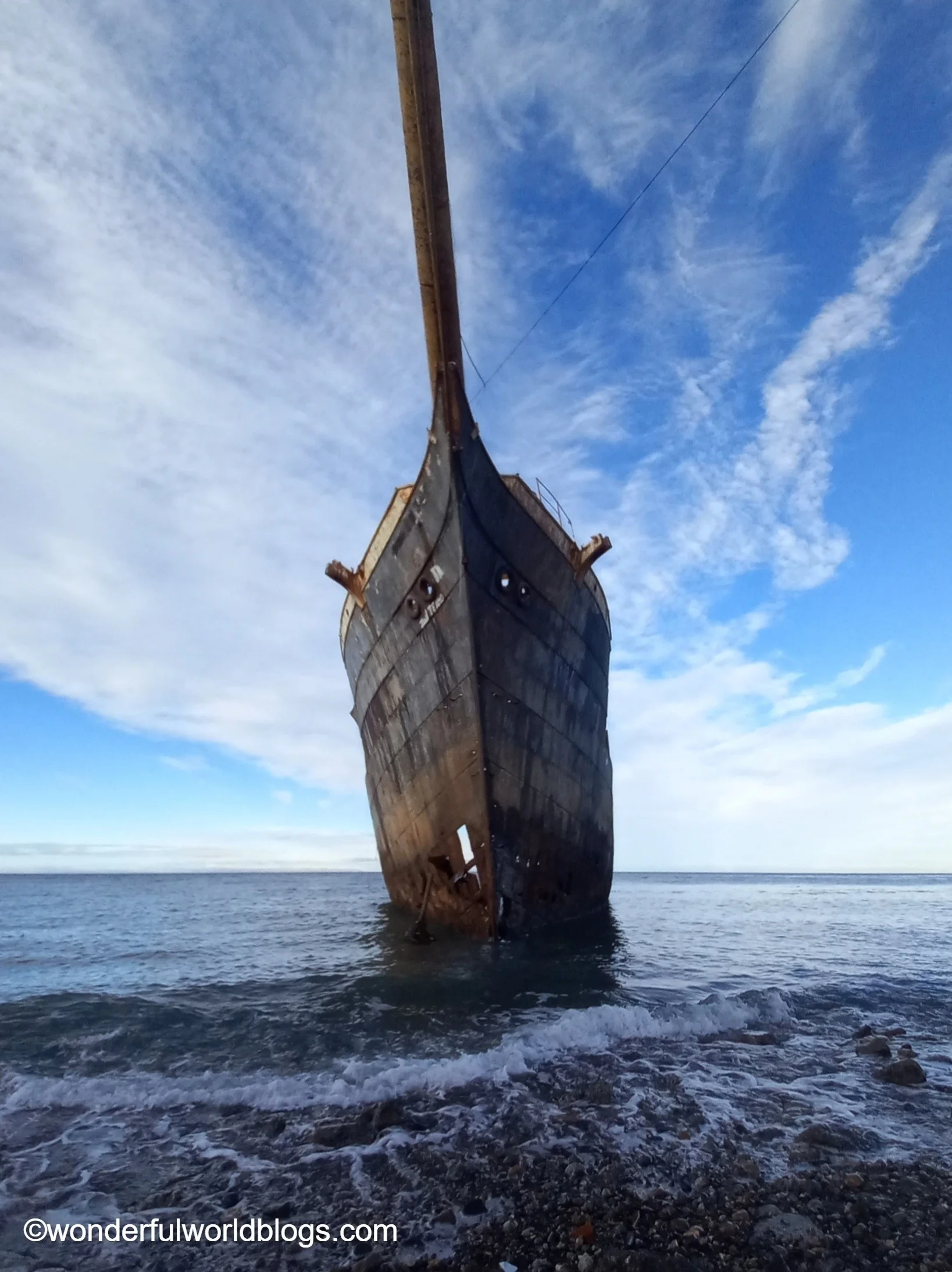
Outside Punta Arenas there lies a huge shipwreck like a beached whale, flesh torn off its ribs by countless animals, exposing its innards to the harsh southern winds. Her bowsprit, like the tusk of a narwhal, thrusts inland instead of seaward, her final journey at an end, water sploshing through mortal wounds in her sides. As she slowly crumbles into the ocean, a sad but majestic reminder of her epic voyages and long silent crew, her rails have become perches for small seabirds now, instead of her, and for evermore, the masters of the winds and tides.
Before darkness fell I hurried along to the town's cemetery. (Not that hurrying to a cemetery is something you would normally plan to do. "Can you tell me the way to the cemetery?" "Just keep going the way you are, my friend, and you will reach there soon enough.") Here, even after death, social competition rules. The richest families have the largest, most ornate tombs in the centre while, passing along scenic rows of trees, the tombs decrease in size until, side by side on the outer walls like safety deposit boxes, sit little family shrines, adorned with withered flowers and faded photographs.
Walking back down the street afterwards I felt an end approaching too. Not my own just yet, but the end of my journey, as I booked my ticket across the Straight of Magellan to Ushuaia, and land's end.
I set off from Punta Arenas for Ushuaia in the company of a rather sleepy bunch of Mexican ice-hockey players. After the inevitable fiesta the night before they were on their way to play in La Copa del Fin Del Mundo (The Cup of the End of the World). After two hours we boarded a ferry across the fabled Estrecho de Magallanes, once navigated by Francis Drake, de Gamboa, James Cook and Charles Darwin, to name but a few. For centuries this was the most important natural waterway connecting the Atlantic and the Pacific but, due to the Panama Canal, when I crossed there was not another ship in sight.
Tierra del Fuego
The Land of Fire gained its name from the campfires that Magellan's crew spied. Now, ironically, the lighting of fires is strictly prohibited. The complicated network of channels that surround it confused sailors and wrecked their ships for centuries, and these islands and their snowy peaks were one of the last parts of the globe to be settled, about 9000 years ago. La Tierra was inhabited by the hunting tribes of the Selk'nam and Haush and the fishing people, Yámana and Alacalufe. For thousands of years, before the establishment of permanent bases on Antarctica, they were the most southerly people on the planet. Rather than being primitive, as the first Europeans thought, they were incredibly capable and resilient people, entirely in tune with their harsh environment. Sadly these unique tribes disappeared a century ago due to the invasion of European settlers and the diseases they brought with them.
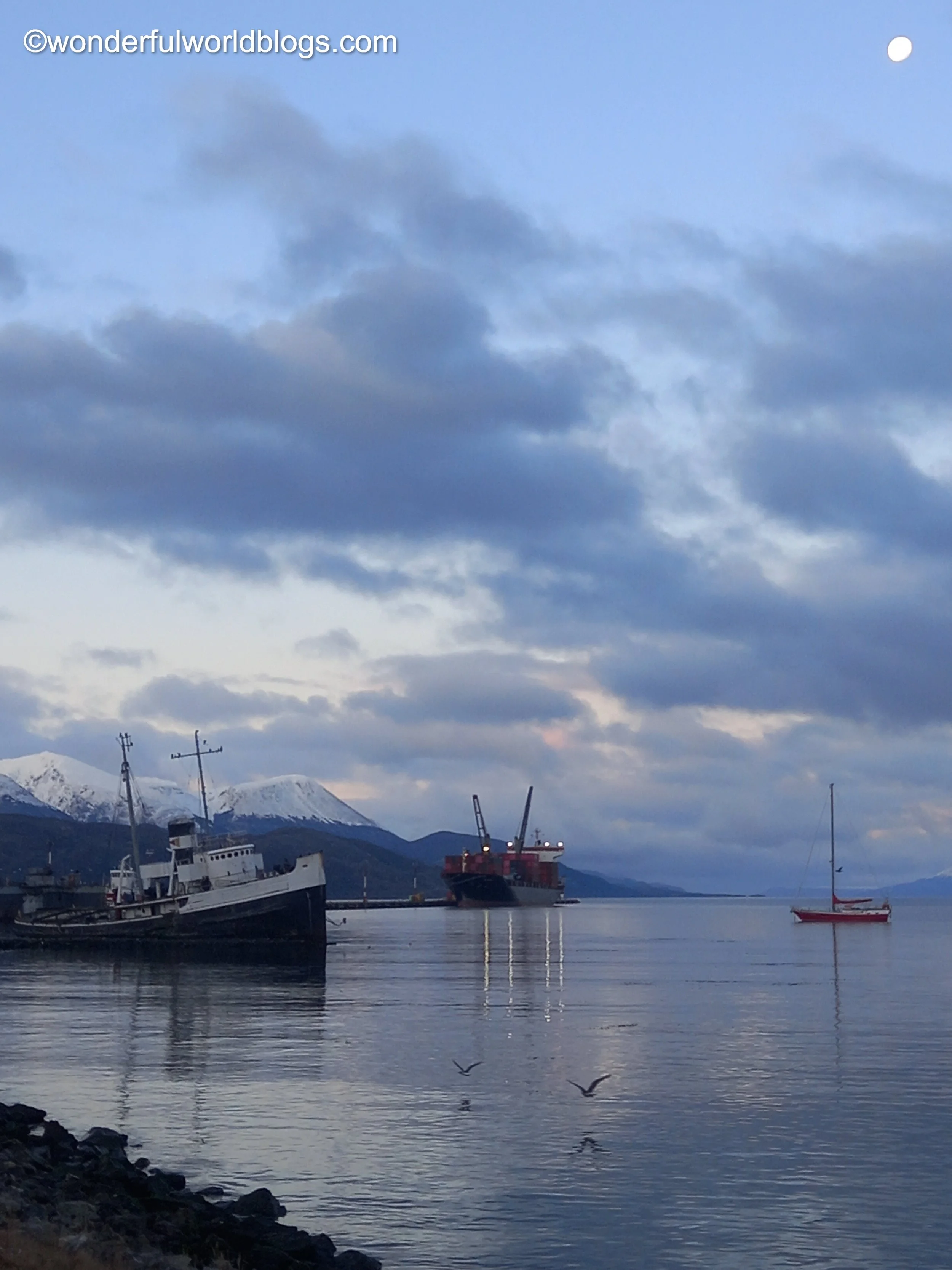
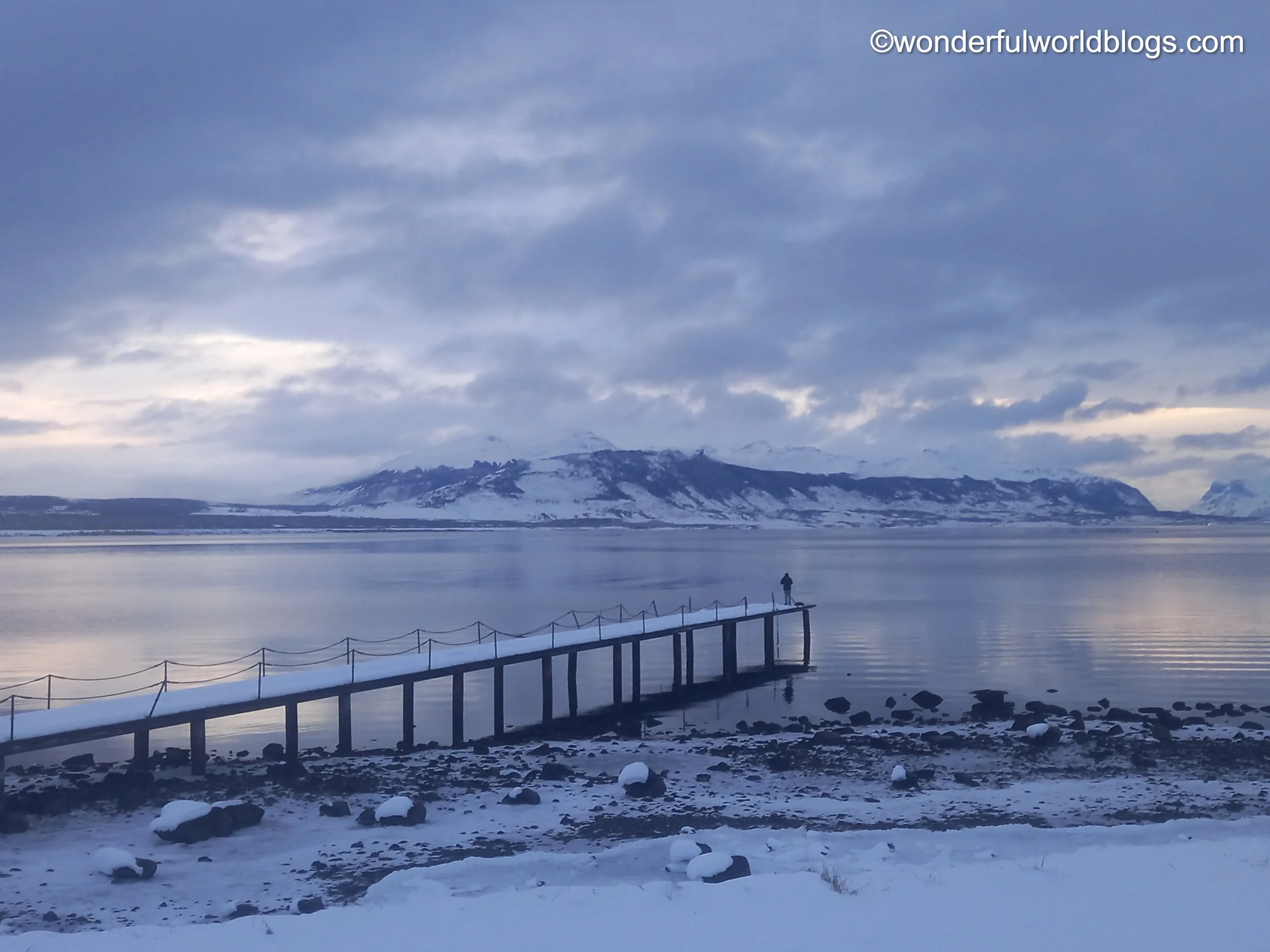
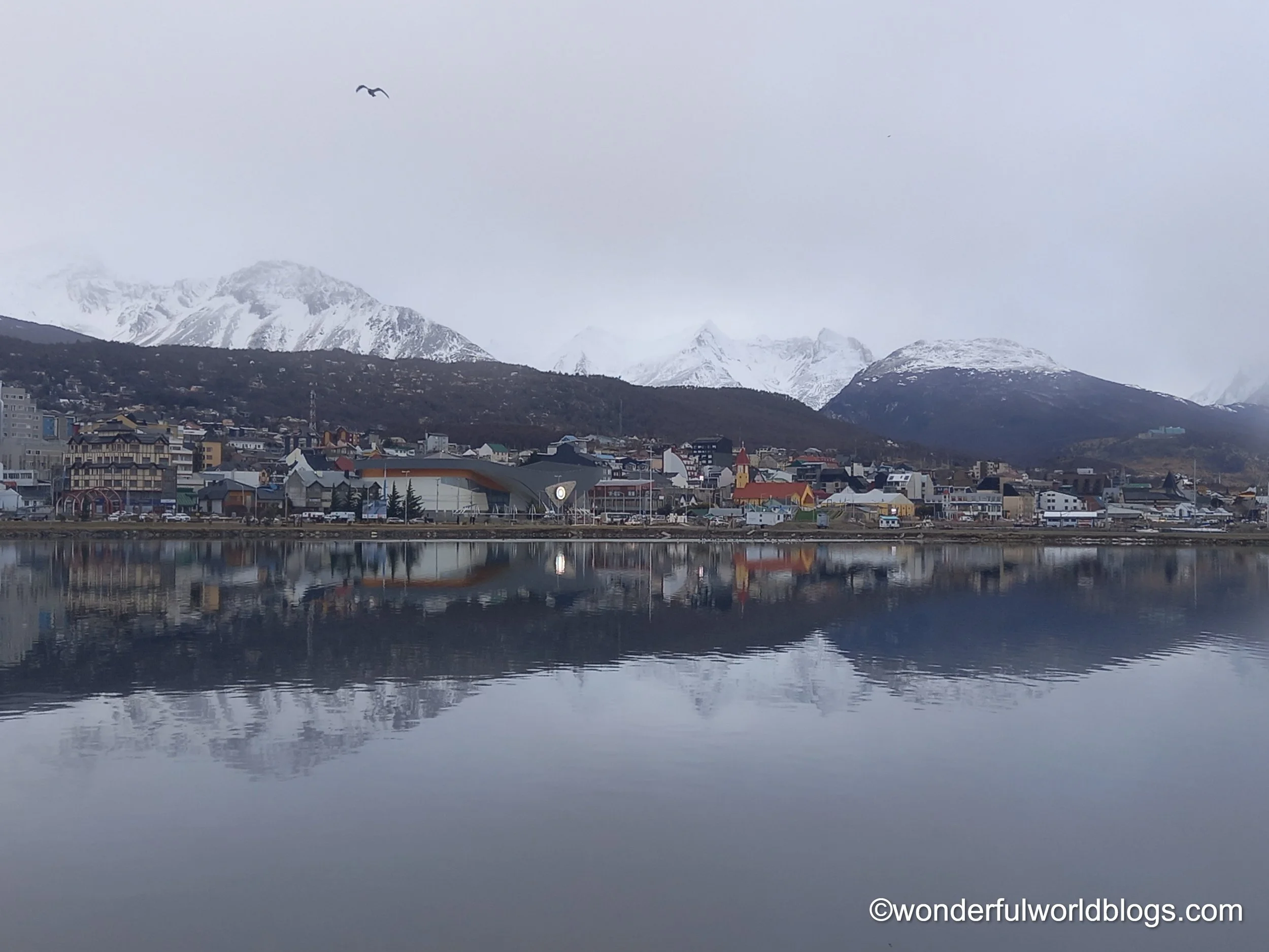
La Tierra del Fuego is one of the few islands in the world divided by a border. From this featureless frontera the road takes a circuitous route to Ushuaia, a full ten hours by bus from Punta Arenas, though not nearly as far as the condor flies. The city, the most southernmost in the world, is situated on the banks of the Beagle Channel and surrounded by a dramatic backdrop of white peaks. Rising up from the port (overseen by a man whom I happily found out was from Rapanui), from where in season Antarctica-bound vessels depart, are seafood restaurants from whose windows unfortunate giant crabs stare out at you, and the world's most southernmost Irish bar, where I immediately found a home with my new Mexican friends.
Ushuaia
Ushuaia, from the Yámana words ushu, meaning "in the background", and uaia, "bay", is twinned with the most northernmost city in the world, Hammerfest in Norway. Founded in 1884 on the site of a former Anglican mission for the next sixty years the city was best known for its prison, in whose claustrophobic cells were held political prisoners and Argentina's first serial killer Cayetano Santos Godino, nicknamed El Petiso Orejudo, "The Big Eared Short One". Although built with thick walls the institution didn't have particularly secure fences as escape from this remote settlement, where until the mid-20th century there was only one boat every six months, was deemed impossible (no-one ever succeeded). The prisoners were kept busy building the line for El Tren del Fin del Mundo, and boosted their spirits through sports and art, carving elaborate furniture and painting colourful landscapes that they no doubt longed to visit.
In Ushuaia I joined El Club de Fans of the Mexican men's and women's ice-hockey teams, whose friendly players complained bitterly about the biased Argentinian referees over innumerable pints of beer. I saw frozen lakes and lighthouses, met wild horses and hungry little birds, and was assaulted by the sound and smell of penguins and sealions issuing forth from their rocky homes in the Beagle Channel.
On my final day I trekked to the Vinciguerra glacier, wading through occasionally waist-deep snow, and made my way up a frozen valley through ancient woods whose trees rose up like the columns of great cathedrals. There I reached the most southerly point of my entire journey. I had wanted to go further, to the Isla Navarino and perhaps even to Cape Horn, but it is impossible in winter without your own boat. In a high snowy pass, due to the risk of avalanches, I could go no further. And so I turned back as the sun set behind the lonely ridge above, suddenly realising that from now on I would be heading for home at last, half a world away.
I have travelled to one of the planet's most isolated places and to its most southerly city. I have seen volcanoes, impossible peaks, great glaciers, the gaping mouth of the Cave of the Milodon and felt the presence of the moai. But it is the people I have met in these far-flung places that will remain with me most strongly. The footsteps of my fellow walkers guiding my frozen feet through the snow; the fishing trip with Rapanui and the late-night party around the fire; the familiar faces at the world's most southerly Irish bar; being greeted with garlands of flowers and departing with necklaces of sea-shells, and the happiness and tears of parting from new, dear friends. But while sailors once set off on voyages that lasted many years, from which some never returned, today we know that we can see familiar faces again, if we wish, before too long.
©wonderfulworldblogs.com